Published on July 17, 2023
The Planning Board will begin discussion and hold a public hearing on the substance of the Carr Woods Final subdivision and Resource Protection Permit application on Tuesday, July 18, 2023. The board voted in favor of the project’s completeness during the June 20 Planning Board meeting with a 4-0 vote and passed a second motion to table the application until a public hearing on July 18. Board member Andrew Gilbert recused himself from the vote. Board members Derek LaVallee and Alton Palmer were absent. Board member Jim Huebener said that by voting the application complete, “It does not mean that the we [the board] agrees with everything that is in the package; it just means that the information has been submitted.”
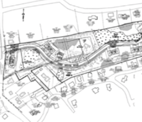
Andrew Carr, Debra Carr, and Ena Hanson are co-applicants seeking to build a 16-unit condominium and one single family home lot subdivision located at Deep Brook Road. The project has undergone various updates since March of 2021. This includes two requests made by the applicant to extend the submission due date of the Final Subdivision application on January 17 and March 21 of 2023. A March 3 letter from the applicant’s attorney, Gordon Smith of Verrill Dana LLP, informed the Planning Board that the extension was being requested because, “The original purchaser and developer for Carr Woods has withdrawn from the project.” Per Chapter 16, Subdivision Ordinance, a Major Subdivision Plan must supply a Final Submission within six months of receiving preliminary approval. The Carr Woods application received preliminary approval on August 16, 2022.
At the June 20 meeting, Smith explained that Shore Road Development Partners LLC would be the new purchaser and developer, as well being listed as a co-applicant for the project. Smith indicated that the Purchase and Sale Agreement was being worked on and anticipated it would be finalized within the coming weeks. Shore Road Development Partners and their attorney Kristin Collins of Preti Flaherty, also attended the meeting. Speaking to the project’s completeness, Collins confirmed that information on the purchasers’ technical and financial capacity had been submitted, as had a letter from their potential lender in support of financing the project.
Bill Gerrish, the civil engineer from Northeast Civil Solutions, reviewed changes made to the project since having received preliminary approval and addressed the conditions tied with the approval. One of the conditions was that the applicant receive feedback from the Conservation Committee on the project’s proposed trail network. Based on their conversation at a June 13 Conservation Committee meeting, a decision was made to remove the trail network and “A number of changes were made to enhance the open space plan.”
Another significant change was the removal of one duplex unit which allowed for an increase to the open space. More subtle changes are seen in the scaling back of “detention basin number one.” “We were able to redesign that detention area and but a catch basin in the base of it and still achieve the detention storage that was needed,” Gerrish said. The area identified as “underdrain soil-filter number 2” was made longer and narrower, “To maintain a 50-foot strip of undeveloped land between the boundary line and the embankment of the underdrain soil filter to enhance the overall open space plan,” Gerrish added. The overall undisturbed open space is over 47%, which exceeds the 45% requirement. The overall open space being provided by the project is over 60% and useable open space is 76% -- which subtracts out RP1 wetlands, flood zone areas, steeped slopes in excess of 1 acre or more, exposed bedrock, utilities, and rights of way – also exceeds the requirement of 33%.
Gerrish also indicated that the completeness requirement of a standard boundary survey was provided in the final submission. The survey shows that there is one area that includes a deed overlap near the rear boundary line. This creates a wedge-shaped area where the deed title could be in question. Town Planner Maureen O’Meara explained that the ownership of the deed overlap, “Needs to be resolved now,” and that the deeds to the open space areas also need to be provided.
During the public comment portion of the meeting, speakers raised concerns regarding incomplete proof of financial and technical capabilities. One abutter said, “Our nightmare scenario is that this project gets as far as clearing and some infrastructure, and then goes sideways with site-plan infringements and/or financial collapse; the developers abandoning the site before completion, leaving a tragic environmental mess behind." Another abutter suggested that the project, “Shouldn’t be deemed complete until there is an actual contract in place,” with a financial institution.
In response, Smith, responded that while a purchase and sale agreement is pending finalization, “There is never going to be a binding legal agreement between a financial institution and a project prior to the permit issuance. Once the permit is issued the parties will close on financing and it’s at that point that the lender becomes legally obligated.”