News
05/23/2011
Community meeting eyes management plan for Trout Brook watershed
Community Meeting
6:30-9 p.m. Thursday, June 9, 2011
South Portland Planning Department
496 Ocean St., South Portland (directions).
For more information please see
Cumberland County Soil and Water Conservation District website.
A community meeting on a management plan for the Trout Brook Watershed will be held from 6:30-9 p.m. Thursday, June 9, 2011 at the South Portland Planning Department on Ocean Street in South Portland (directions).
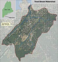
The City of South Portland was recently awarded a grant from the Department of Environmental Protection to develop a management plan for Trout Brook, a 2.9 mile stream that runs along the northeastern South Portland/Cape Elizabeth boundary and drains into Casco Bay at Mill Cove (next to Hannaford).
The land that drains into the brook has been has been identified as an urban impaired watershed. Development in these areas has led to increased and polluted stormwater runoff. Neither the Cape Elizabeth or South Portland areas of the brook meet state water quality standards.
In 2007, Cape Elizabeth adopted a fee schedule for development in the watershed to help mitigate existing polluting conditions, as required by the DEP. Mitigation projects include collection of pollution data and restoration of buffers between the stream and developed properties. [see news article]
The management plan will outline further strategies to fix existing stormwater and habitat problems in developed parts of the watershed, and work to reduce impacts from future development in planned growth areas.
For watershed maps more information, please see the Cumberland County Soil and Water Conservation District website.